


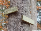
 Description for Stewart Hollow Brook Lean-to in CT: Sign

Description by refreeman

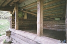
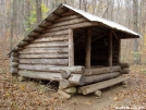
Stewart Hollow Brook Lean-to
County/State: Litchfield CT, Elevation: 425', Capacity: 6
1459.1 miles from Springer and 715.5 miles to Katahdin
next shelter south,Mt. Algo Lean-to, 7.3 miles. next shelter north, Pine Swamp Brook Lean-to, 10.0 miles.
Maintained by: AMC - Connecticut Chapter
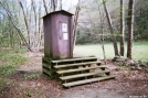
Perfect water source nearby (Housatonic River), composting privy, many excellent tent sites.
-
#1

Re: Stewart Hollow Brook Lean-to in CT: Sign
Had a lot of mice, even in the daytime 3 years ago. They chewed through a hikers hat


Comments for Stewart Hollow Brook Lean-to in CT: Sign (1)