


 Description for Iron Bridge Map Rendering

Description by Manwich

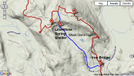
Iron Bridge Map Rendering
-
#1
Re: Iron Bridge Map Rendering
The Red is correct. -
#2

Re: Iron Bridge Map Rendering
The red is a relocation from a former route -
#3
10-16-2014 13:22

Re: Iron Bridge Map Rendering
the blue comes in handy if the weather's too bad to get back out of the campsite up to the AT! Saw some locals doing blue to red loop while camping there.


Comments for Iron Bridge Map Rendering (5)