


 Description for PA flooding

Description by knicksin2010

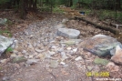
This is a tributary to the trail just south of RT 81 in PA. The trail itself was under well over 6 feet of water for 30 feet. The picture was taken June 27, 2006.
-
#1

Wow. That's impressive.
-
#2
12-21-2011 20:18

Re: PA flooding
wow, looks like fun ... i've lived in pa all my life and never seen such a thing on the trail ... thats truely wild! -
#3
04-21-2012 09:50

Re: PA flooding
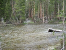
Yep, I hiked PA in '06 as well. Spent entire days hiking in calf to knee deep water. I also detoured onto I-81 around the 6' deep sections of trail just north of the Iron Bridge at Swatara. Also hitched a ride on a log skidder to cross a creek just north of Peter's Mountain Shelter.The spring in front of Rausch Gap Shelter was "flowing" like a 2" fire hose. Had to really hold onto your pots to avoid loosing them.Fun Times.


Comments for PA flooding (3)