


 Description for A. T. North Of "Raven Rock," Md, 06/06/09

Description by Irish Eddy

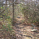
North of "Raven Rock," the A.T. continues its ascent from approximately 1300 feet elevation to approximately 1650 feet elevation. Along the way, the A.T. circumvents a number of large rock formations. Here the A.T. begins to level out as it nears the top of the mountain. This is a view from the A.T. looking north from a location approximately 0.9 mile north of Raven Rock Road, MD Route 491. After a sometimes steep ascent from Raven Rock Road, the ferns are a nice change of scenery. SoBo 1128.9. NoBo 1049.4.


Comments for A. T. North Of "Raven Rock," Md, 06/06/09 (0)