WhiteBlaze Pages 2024
A Complete Appalachian Trail Guidebook.
AVAILABLE NOW. $4 for interactive PDF(smartphone version)
Read more here WhiteBlaze Pages Store

The Route from/to Daleville

Added by Kerosene
« Previous Image   |   Next Image »

The Route from/to Daleville

Views: 5,018  
 
Filmstrip 
‹‹Base of Tinker Cliffs   Sunrise over Trout Creek Valley  The Route from/to Daleville  Fogged in Carvins Cove Reservoir

  Description for The Route from/to Daleville

Description by Kerosene

Kerosene

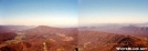
A spliced panoramic view from McAfee Knob showing the AT route along the ridgelines around Carvins Cove reservoir, including Tinker Cliffs in the left-center. Distance from this point to the summit of the rightmost summit on the ridge is about 14 miles. Distance to Daleville is 16 miles.

Comments for The Route from/to Daleville (4)

  1. #1 Uncle Wayne
    Durn power line!
  2. #2 Hikerhead
    That's about 15 miles of trail in your picture.
  3. #3 Gray Blazer
    Re: The Route from/to Daleville
    That's what I'm talking about!
  4. #4 Blissful
    Re: The Route from/to Daleville
    Great, thanks!