


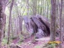
 Description for Mt Mitchell

Description by Grits

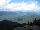
From Mt. Craig looking west towards Mt. Mitchell on the left
-
#1

Re: Mt Mitchell
I learned a lot by studying your pic. Very high resolution. I enlarged it quite a bit. I learned that Mt Craig is the second highest peak in the East (I thought Clingmans Dome was the second, but, it is the third.) Good view of parking lot on left. The ridge I'm guessing is Balsam Ridge with parkway on the highest Mt in the middle. One of the mountains in the background should be Mt Sterling. Just to the left of the 2nd highest on the fore ridge should be Mt Mitchel way in the background with the prominent Blacks with the drop off to the Toe River. I don't know what the mountain is with the two towers, but, Water Rock knob should be visable as well. -
#2
09-09-2009 18:21
Re: Mt Mitchell
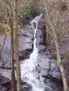
The radio towers are on Clingmans Knob near the intersection of the Parkway and Hwy 128 that goes up to Mt Mitchell State Park. You are correct that is Balsam Gap and the ridge is called Balsam Ridge/bearwallow Stand Ridge. Mitchell Ridge is at the right of the picture and leads down to Mitchell Falls. Burnsville and the community of Pensacola can be seen further to the north. Before it got hazy and is not clear in the picture you can see Big Bald on the North side of the County along the AT. Just learning how to merge pictures so it is not perfect. The river along that side of the mtn is the Caine River the Toe is on the east side of the ridge. -
#3

Re: Mt Mitchell
Another of my favorite stomping grounds. Mt Mitchell..only 53 miles away ..


Comments for Mt Mitchell (3)