


 Description for Plumorchard Shelter

Description by Youngblood

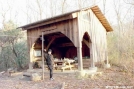
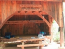
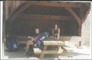
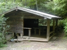
The Plumorchard Shelter is the closest shelter in Georgia to the North Carolina border, it is 71.1 miles north of Springer and sleeps about 14 people on its sleeping platform and two lofts.
-
#1
06-21-2003 15:07
Also 0.2 miles and a little bit more off trail down steep blue blazed trail.
Sugestion for the weary, use very nice camp site immediately to right of AT Plumarchard Gap sign (like immediately, aka a few feet) indicating location, do not recommend hike to left to alternate water source. Both water sources are an effort when tired.
Water source to shelter is the better option, leave pack at sign if continuing on to Bly as climb back up spring is an effort after climb up from Cowarts Gap over Bull Gap to this point.
Climb up from Plumorchard Gap appears steep from map, but I found it relatively easy, harder, continuous climb lies ahead.
Lookd for an interesting camp site shortly after what I belive to be Rich Cove Gap, to your left, you will see small stream, clearing, and above clearing what appears to be a rock alter with clear views.


Comments for Plumorchard Shelter (1)