


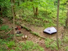
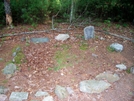

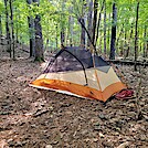
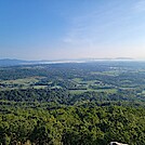
 Description for Wildcat Top

Description by SmokyMtn Hiker

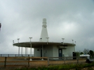
FAA control facility on Wildcat Top
-
#1

Re: Wildcat Top
Looks pert-near like the one on Snowbird Mountain, just north of I-40.
What is the date of the photo, please?
Rain Man
Man
. -
#2
Re: Wildcat Top
I walked right past this and didn't see it....it was foggy. The FAA decommissioned one of these on Potts Mtn (next mtn east of Peters Mtn in Va) and my dad and some buddies rented it out and used it as a hunting camp for about 15 years. -
#3

Re: Wildcat Top
Are you sure you just weren't looking at your feet as you slogged up the hill? Originally Posted by Hikerhead
")
-
#4
Re: Wildcat Top
Might have been, I wasn't afraid of getting caught away from shelter before the sun went down.
-
#5
Re: Wildcat Top
Photo taken Memorial weekend 2008 and it is the on Snowbird just north of I-40. The map or something I had called that spot Wildcat Top. Originally Posted by Rain Man
-
#6

Re: Wildcat Top
I slept under this one back in 84'


Comments for Wildcat Top (6)