


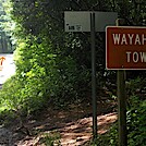
 Description for Wayah Gap Parking

Description by GoldenBear

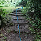
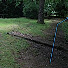
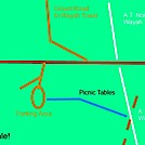
Schematic map of the area of Wayah Gap. Highway 1310 (Wayah Road) is in red, gravel roads are in brown, the A.T. is in white, the walk from the parking area to the A.T. is in blue, and an old road that crosses over the A.t. is in dotted brown. When walking from the parking area to the A.T., it is easy (and tempting) to follow that road instead of the actual trail, but resist temptation!


Comments for Wayah Gap Parking (0)