


 Description for Abandoned Farm in TN

Description by LovelyDay

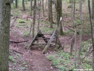
5/24/2006 - Follow the white blazes through this abandonded farm in Tennessee
-
#1

Re: Abandoned Farm in TN
what's the lat/long......if there's water available...i'll camp there 4 a few months -
#2

Re: Abandoned Farm in TN
Its the old Osborne Farm right at the intersection of TN Highway 91 & Cross Mountain Road just above Shady Valley TN. Its on the Cross Mtn ridge crossing from Iron Mtn to Holston Mountain. The ATC acquired it a few years ago. We at the TEHCC just opened most of the farm trail as wheelchair accessible grade and then built an accessible stile within the last few months.
For camping, you probably want to follow the trail all the way back to the forest edge to get away from the road. But this is a popular place for day hikers and picnicers. There is ample parking at a lot across from the farm. And the forest service is looking into grazing cattle on the land.
I believe there is an old cranberry bog and cabin, past the forest edge, further up the farm road. There is no immediate open springs on the property. The bog may dry up at times. There is a spring about a mile southbound from the farm along some bog bridges. Another one northbound from the farm toward Double Springs. There should be some springs west of the property down in some steep ravines but none have been opened to the trail.
Double Springs Shelter is about a couple miles further, with a campsite on the way.
Water wise -
#3
12-12-2008 15:44

Re: Abandoned Farm in TN
Update as of about 7/1/08
The AT no longer is on the farm road but is about 50' trail east, going to the right of the long shed. Water is S as stated above, I do not remember water N, but there may be. The shed just visible on the L side of the pic is still (mostly) weather tight if you need shelter in an emergency.


Comments for Abandoned Farm in TN (3)