


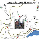

 Description for Longsdale Loop 58 mile 5 day hike

Description by Aquonehostel

North Carolina Longsdale Loop
5 Day, 58 mile hike:
"Hikers seeking a great hike should consider the 58 mile loop hike, utilizing the Appalachian and NC Bartram Trails, starting and ending at Aquone Hostel, Nantahala NC. 1-828-321-2340
Since this hike starts and finishes at the same place, Aquone Hostel can be used as a "base camp". This will allow you to take advantage of Aquone Hostel lodging and great home cooked country food, the night before and the night after the hike.
You can leave your vehicle at the Hostel and arrange a shuttle to the start point, arrange for pick-up along the route. Dont forget to ask about our slack-packing, this way you enjoy the hike with the minimum amount of discomfort. 1 828 321 2340
Day One 8.1 miles: The hike starts out on the Bartram trail (BT) (Yellow Blaze) at Nantahala Lake (SR 1310) Aquone hostel will shuttle you to the start point and will advise where necessary. The climb out from the lake is very steep, so aim to take it easy, plan to have lunch at FR711, the hike from there is a lot easier. At some point the AT will join the BT and both trails will guide you to Wayah Bald, do spend some time at Wayah Bald Tower 5,342 the views are outstanding. The AT and BT, will guide you from the tower, loosing height until the AT & BT go their separate ways. Note: The AT will turn left and the BT will turn right ( To Franklin), make sure you follow the White Blaze, not Yellow. A short distance down the AT you will come to Wayah Shelter 4759, this is where you will spend your first night.
Day Two: Wayah Shelter to Wesser Shelter (10.6 miles), After a good night's rest and breakfast at Wayah Shelter a nice easy hike to Wesser Shelter 4115, take the AT North to Cold Springs Shelter (4.8 miles) where I recommend you have lunch. Water is available here, be sure to treat or filter the water. Once again take the AT North to Telico Gap (3.6 miles). Please note this is a Hostel Pick-up point should you wish to spend the night 1-828-321-2340 you can call just before or from the gap, reception is poor so you may have to move around a little to get a decent signal. The distance from Telico Gap to Wesser shelter miles, is 2.2 with quite a hard climb to Wesser Tower 4,627 feet, so take your time, the views are outstanding so its worth the climb. Note: The Water Point is 150 yards above the shelter, and you will pass it on your way in so do stop and fill-up before arrival at the shelter.
Day Three: From Wesser Shelter to Sassafras Shelter 4330 (12.6 miles) Take the trail North to the NOC SR 19 (5.7 miles), the trail is very strenuous practically downhill all the way and can be very demanding on your knees and ankle joints, so take your time. NOC (2,100) is a great place to have lunch and they serve outstanding Hiker-Burgers. After lunch cross the bridge and rail tracks at the NOC and begin your ascent to Sassafras Shelter 6.9 miles where you will spend the night, take plenty of water breaks and frequent stops, because of the tremendous height gain.
Day Four: Sassafras Shelter to Percy Creek Campsite (15.8 miles) Take the AT North 1.1 miles to Cheoah Bald 5,064 where the trail will join section 7 of the Bartram Trail, this is the Northern Terminus of the BT in NC, follow the white & yellow blazes until the AT will head North and the BT will head South, take the BT south (Yellow Blaze) descending 8.6 miles to the hydro Power-Plant Nantahala White Water put-in point 2,212. (Some of the trail will cross the railway track and follow a cycle trail for 1.5 miles. This is a good lunch spot and a Hostel Pick-up point should you wish to return to the hostel. Looking at the Power-Plant the trail-head (section 6) is on the right, follow the gravel road up to the water tower, where the trail will then enter the forest, follow the trail 5.6 miles to Percy Creek campsite, there are several springs and creeks here, an ideal place to spend the night.
Day Five: Percy Creek Campsite to Nantahala Lake (10.9 & Finish) Head South on the Bartram trail to Appletree Campsite (5.6 miles), you will meet Junaluska Road and also a trail-head sign, this is also a Hostel Pick-up point. Continue by crossing the road and walk a 20 yards to your right, you will see the trail follows a gravel road to below Nantahala Dam (2.9 miles), from the dam base climb some steps and follow the trail into the forest, there are some great views of Nantahala Lake 3013 as it takes you to your finish point (2.4 miles)
I highly recommend that the Bartram Trail Maps be obtained and used in planning any hike on the Bartram. The maps are available on the NC Bartram Trail Society website online store. http://ncbartramtrail.org (or available at Ranger Stations). The cost is only $15.00 for the entire set of seven maps, and you can use maps 1-4 to plan your hikes of the rest of the NC Bartram Trail. You may also want to consider becoming a member of the NC Bartram Trail Society.
As you hike the NC Bartram Trail, keep in mind that you will be taking a trip back in early US history. The trail follows, as near as possible, the travels of William Bartram through the beautiful mountains of Western North Carolina in the mid 1770's
It's possible to make this a 3 day, 40 mile hike or less by getting a shuttle from Aqoune Hostel and arranging to be met at any of the Hostel Pick-up points.


Comments for Longsdale Loop 58 mile 5 day hike (0)