


 Description for Direction Markings for Spring

Description by GoldenBear

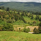
About 1.5 miles north of Rice Field Shelter is the ONLY water you can even hope to find between Rice Field and Swamp Branch Creek -- a walk, through a lot of open fields, of over ten miles. As of mid-July, this spring is bubbling but not bursting with liquid. The spring is downhill from a large camping area, and this marker shows where to go to get to the water.


Comments for Direction Markings for Spring (0)