


 Description for Rand's View: Labeled

Description by refreeman

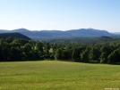
Rand's View: Labeled. The picture says it all.
-
#1

Re: Rand's View: Labeled
Neat, but it was much colder when I went through in March 1975. I almost succumbed to hypothermia climbing up Everett via Jugg End (there used to be a lean-to just below the summit); I almost fell into a snowmelt-swollen Sages Ravine the next day; and then the sun came out and we baked during our ascent of Bear Mountain. I don't think that any of the shelters or campsites were around back then. -
#2

Re: Rand's View: Labeled
Great photo. One thing - Jug End is obscured, from this angle, by Mt. Everett. The area labeled here as Jug End is the eastward shoulder of Everett, unnamed so far as I know. It peaks at about 2050, with an intermediate peak, between it and Ev and slightly northward, at about 2222 or so. Love how clear this image is - did you get Greylock that day, too? -
#3
Re: Rand's View: Labeled
One of the most underrated, least-talked about scenic views on the entire Appalachian Trail, IMO. Heading northbound you leave the dark woods and then, BOOM!, you're out in this sudden display of open space of green grass and a dramatic view of a looming mountain range. A WOW! moment, for sure. Love it.


Comments for Rand's View: Labeled (3)