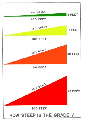
What is the steepest grade that you ever walked up? I've walked up a side trail on the Horseshoe. (Near Gov. Dick, by the old Radar tower site.) It had to be over 20%, near the top! OUCH!
there's a AT section in the Smokies, on the East side of Brier Knob, that's 22%.
I have no idea what the grade was but going up Katahdin is the steepest I have ever attempted to climb. Not fun, yet such a feeling of accomplishment in the end.
i thought the last pitch to the top of everest was kinda tough
Hmm, over how long a distance? Some of the fall line trails in the Catskills ascend 600 feet in a quarter-mile (maybe even 1200 feet in a half-mile), about a 50% grade for that short distance. The fall line trails in the Adirondacks, northern Vermont, the Whites and the Mahoosucs have similar grades over the quarter mile. That's pretty much a limit for a hiking trail, since much steeper than that and the route is likely to have at least one pitch that requires technical climbing. Some of the ones that I can think of that are that steep are indeed technical ice climbs in winter.
I always know where I am. I'm right here.
There are some places on the CDT in Montana where the trail is so steep it seems unreal that anyone could be expected to get up it. I'm not easily intimidated by inclines but there were a few times I wondered if I was going to be able to get up some sections.
You know its steep when you walk on your toes. Heels dont touch.
Plenty of short AT sections in the White Mountains and in Maine that must exceed 20%, maybe even 40% (like I say, short sections.)
A few that impressed me at the time -- Beaver Brook trail, the climb up South Kinsman, Wildcat, the descent off North Carter, South Arm. And of course Hunt Trail, up Katahdin.
Some of the real kickers are off the AT. (Like Knife Edge at Baxter State Park.)
The one that stands out to me was my very first day on the AT, I started at the NOC (nobo) and camped on top of Cheoah bald 8 miles later... well, the last half mile or so before getting to the top of Cheoah bald was crazy steep with a full pack!
The short bit on the way up to Albert Mountain fire tower was steeper - had to use hands AND feet to get up those rocks.
A 20% grade is just a normal trail around here.
I know of several trails in my area that are 45% or actually worse---handholds up vertically onto rocks and tree roots (the Upper Slickrock #42 Nutbuster trail comes to mind in NC).
Here are some bad ones---
**Panther Creek near the top (a trail veering off Tellico River in the Cherokee NF).
**Hangover Lead North Trail between Big Fat Gap and Yellowhammer Gap in NC.
Walter,
You are bang-on. A trail which *doesn't* have at least a short section of 20% grade is probably a paved road in town.
A better question for this thread would be, "Over the course of a mile or longer, what is the steepest grade you have ever hiked?"
For short distances of 0.25 or 0.5 miles, I'd say the Adirondacks have some of the steepest sections that I've hiked (eg, climbing the slide up to Gothics Mountain). Or the last 0.25 miles climbing up Camel's Hump in Vermont is pretty steep too. But over a full mile or more? A 30% grade over a mile is pretty ridiculous. I've hiked some stretches in the Pyrenees that would be roughly that, but I don't recall too many.
I believe this data is from Guthook on another Whiteblaze thread:
Steepest 0.5 mile stretches:
Section 1 from 1865.5 to 1866.0 with 1017 change --Pinkham Notch to Wildcat E (2000' in 1.5m)
Section 2 from 1794.3 to 1794.8 with 934 change -- Asquam Ridge Trail toKinsman Notch (2180' in 1.7m)
Section 3 from 1824.2 to 1824.7 with 896 change -- Galehead to South Twin(1130' in 0.8m)
Section 4 from 1821.2 to 1821.7 with 875 change -- Northbound from Mt Garfield(970' in 0.6m)
Section 5 from 2182.1 to 2182.6 with 860 change -- O Joy Brook to The Gateway(2120' in 1.4m)
Section 6 from 1908.2 to 1908.7 with 850 change -- Mahoosuc Arm (1600' in 1.4m)
Section 7 from 1869.9 to 1870.4 with 846 change -- Carter Notch to Carter Dome(1530' in 1.1m)
Section 8 from 1934.5 to 1935.0 with 812 change -- South Arm Rd to Old Blue(2180' in 2.6m)
Section 9 from 1790.4 to 1790.9 with 801 change -- South Peak Moosilauke(total, 2920' in 3.0m)
Section 10 from 1932.2 to 1932.7 with 799 change -- Sawyer Notch to Moody Mtn(1300' in 1.3m)
Steepest 1 mile stretches:
1 - 1794.1 to 1795.1, 1760': Asquam Ridge Trail to Kinsman Notch (2180' in 1.7m)
2 - 2181.6 to 2182.6, 1640': O Joy Brook to The Gateway (2120' in 1.4m)
3 - 1858.6 to 1859.6, 1640': Mt Madison to Osgood Tentsite (2850' in 2.3m)
4 - 1865.6 to 1866.6, 1500': Pinkham Notch to Wildcat E (2000' in 1.5m)
5 - 1869.9 to 1870.9, 1430': Carter Notch to Carter Dome (1530' in 1.1m)**
6 - 1813.4 to 1814.4, 1420': Liberty Brook to Franconia Ridge Trail (2180' in 1.8m)
7 - 1880.1 to 1881.1, 1360': Just north of Mt Moriah to First Crossing of Rattle River (1600' in 1.3m)
8 - 1930.8 to 1931.8, 1340': Hall Mtn Lean-to to Sawyer Notch (1530' in 1.3m)
9 - 1823.8 to 1824.8, 1330': Galehead Hut to South Twin Mtn (1130' in 0.8m)
10 - 1907.8 to 1908.8, 1330': Mahoosuc Notch to Mahoosuc Arm (1600' in 1.4m)
Trail name Catnapper
The more important question for me, is at what grade do I start noticing it. I can hike all day on a 20% grade, but somewhere around 30% I lose the rhythm. It obviously depends on what kind of shape I'm in, and even my frame of mind at the moment.
The steepest climbs I've been on aren't always the ones I've struggled on. I had a blast climbing up Mt Albert, but struggled coming up from Fontana dam.
I went straight up some mountain around Colorado springs one day it was very steep. Standing up you could reach out and touch the ground a lot. I wouldn't recommend it though trail would have been faster some places were almost technical climbing.
Hiking the AT is “pointless.” What life is not “pointless”? Is it not pointless to work paycheck to paycheck just to conform?.....I want to make my life less ordinary. AWOL
It's been over a decade now but, I remember coming up the Bright Angel Trail in the Grand Canyon there was a section called the "devils corkscrew".......that was steep.
Hope Pass is up to a 21% grade - at an altitude of 12,000+feet! not only is it steep, but there's no oxygen. I've done it twice.
The out of Port Clinton is pretty steep.
Hope Pass is a very stiff but beautiful climb. I was huffing and puffing for the final 1,000 feet of gain. I've only done it once, heading up from Twin, but when I got to the top, I realized that going down the west side seemed even steeper than the east side that I had just climbed!