WhiteBlaze Pages 2024
A Complete Appalachian Trail Guidebook.
AVAILABLE NOW. $4 for interactive PDF(smartphone version)
Read more here WhiteBlaze Pages Store

Page 1 of 2 1 2 LastLast
Results 1 to 20 of 28
  1. #1
    Ricky and his Husky Jack
    Join Date
    05-04-2014
    Location
    Dalton, Georgia, United States
    Age
    40
    Posts
    794
    Images
    14

    Default How far can I hike in the wild from Keown Falls/Johns-overlook?

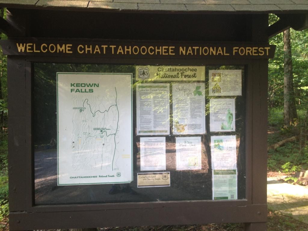
    I live in Dalton, and set foot on the Pinhoti for the first time when I was visiting Keown falls/Johns Mountain overlook (20mi SW of Dalton) with the Chattanooga hiking club.

    I know that N.E of there there is a bit of road walking.

    But I am wondering, If I park at Keown Falls/Johns mountain overlook in the Chattahoochie forrest, how far can I go S.W. of there on the Pinhoti til I come to:

    Road walking
    A re-supply point before heading back.

    I would like to Park near Keown/johns mountain overlook and then hike the pinhoti in the direction of Alabama. But because I hike with my dog, I want to know how long til I am forced to hike on roads, and what is a decent re-supply spot to go to before turning around and hiking back.

    I don't know if that would only be 10miles or 50 miles. So any info on that area would be great.

    heres a few pics of the area, incase I'm confusing you on where Im talking about.
    Me: Ricky
    Husky: Jack
    Skeeter-Beeter Pro Hammock.
    From Dalton, Georgia (65 mi above Altanta, 15mi south of Chattanooga)

  2. #2
    Ricky and his Husky Jack
    Join Date
    05-04-2014
    Location
    Dalton, Georgia, United States
    Age
    40
    Posts
    794
    Images
    14

    Default

    Does the trail go right to Armuchee?

    If so, how far is that from Keown/Johns mountain overlook?

    Im having trouble locate a mileage map showing it
    Me: Ricky
    Husky: Jack
    Skeeter-Beeter Pro Hammock.
    From Dalton, Georgia (65 mi above Altanta, 15mi south of Chattanooga)

  3. #3

    Default

    I had a resupply in Cave Springs Ga going NOBO into Dalton GA where I resupplied again but made a diversion into Rome GA to supplement and check out the history of the area(pretty cool little town). So, I know for sure Rome or possibly resupply at the Evans Store(a gas station w/ a convenience store) at the corner of Hwy 20(into Rome) and Huffaker Rd before the long road walk into Cave Springs SOBO.

  4. #4
    Ricky and his Husky Jack
    Join Date
    05-04-2014
    Location
    Dalton, Georgia, United States
    Age
    40
    Posts
    794
    Images
    14

    Default

    so you didn't re-supply between Rome and Dalton?

    Rome is a bit 'far' from Johns mountain.

    I was hoping I could:

    Drive from home (A)
    Park at (B)
    Hike to AND resupply at Armuchee (C)
    Hike back to (B)


    Me: Ricky
    Husky: Jack
    Skeeter-Beeter Pro Hammock.
    From Dalton, Georgia (65 mi above Altanta, 15mi south of Chattanooga)

  5. #5
    Ricky and his Husky Jack
    Join Date
    05-04-2014
    Location
    Dalton, Georgia, United States
    Age
    40
    Posts
    794
    Images
    14

    Default

    This would probably 2 days/1 night hikes if possible.

    Longer if time allows.

    But I start my new job next week, so it would be nice to have a regular hiking area I can do when i'm free.
    Me: Ricky
    Husky: Jack
    Skeeter-Beeter Pro Hammock.
    From Dalton, Georgia (65 mi above Altanta, 15mi south of Chattanooga)

  6. #6

    Default

    I can't remember if there are resupply opps(either buy or mail) in Amuchee R&J and I don't have the benefit of having my PT topos in front of me. What's supposedly at that Hwy 27/1 road crossing that gives you the idea that resupply there is possible? I'm coming up blank remembering that spot. Be patient. There are a few very helpful souls on WB that live in the area and have an intimate knowledge of PT logistics that goes way beyond what I'm coming up with currently. They'll be chiming in shortly. I don't want to steer you wrong.

  7. #7
    Ricky and his Husky Jack
    Join Date
    05-04-2014
    Location
    Dalton, Georgia, United States
    Age
    40
    Posts
    794
    Images
    14

    Default

    Quote Originally Posted by Dogwood View Post
    I can't remember if there are resupply opps(either buy or mail) in Amuchee R&J and I don't have the benefit of having my PT topos in front of me. What's supposedly at that Hwy 27/1 road crossing that gives you the idea that resupply there is possible? I'm coming up blank remembering that spot. Be patient. There are a few very helpful souls on WB that live in the area and have an intimate knowledge of PT logistics that goes way beyond what I'm coming up with currently. They'll be chiming in shortly. I don't want to steer you wrong.

    Well I only picked Armachee because it looks like a 1-2 day hike from Johns mountain overlook parking area..

    And because Armachee is at the tip of the Chattahoochie forest. So I was thinking since that is the first town I would come across, they would have a store etc to re-supply.

    I also was thinking since Armachee was at the tip of the forest, that after i pass that, it would begin some road walks, since its out of the stet park.

    But Armachee was a total guess, based solely on google maps. I've never been there so I don't know its size or anything.

    I could shoot for further, But it looks like rome and back would be a week long trip and not a quick weekend getaway.
    Me: Ricky
    Husky: Jack
    Skeeter-Beeter Pro Hammock.
    From Dalton, Georgia (65 mi above Altanta, 15mi south of Chattanooga)

  8. #8

    Default

    Again, I can't really say if that would be a potential resupply pt or not. Don't let me convince you one way or the other R&J. I simply don't recall what's there if anything. If there's at least a convenience store that may be all you need though. You'll get better advice in a moment. Be patient.

  9. #9
    Ricky and his Husky Jack
    Join Date
    05-04-2014
    Location
    Dalton, Georgia, United States
    Age
    40
    Posts
    794
    Images
    14

    Default

    no problem. I'm not in a hurry at all.

    The advice you gave me so far is already helpful.

    I just wish the Pinhoti online info was as large as the A.T. But I understand that the 2-3 really informative Pinhoti sites actually did a great job.
    Me: Ricky
    Husky: Jack
    Skeeter-Beeter Pro Hammock.
    From Dalton, Georgia (65 mi above Altanta, 15mi south of Chattanooga)

  10. #10

    Default

    You do know you don't have to go all the way on the PT SOBO, like to Hwy 20 like I did(I was thru-hiking NOBO anyhow which changes resupply logistics anyhow) to access services near/or in Rome? By hitching south at Hwy 27/1 you'll hit large grocery food stores. I have no idea how far the hitches would be though. http://www.mapquest.com/maps?city=Ar...657b3a70d49c37

  11. #11
    Registered User Venchka's Avatar
    Join Date
    02-20-2013
    Location
    Roaring Gap, NC
    Age
    78
    Posts
    8,529

    Default

    Did you use Google maps to find services in Armuchee? My iPhone found a gas station with a phone number. Give them a call. Find out what they have. There is a Food Lion south on 21 at the airport.

    Wayne


    Sent from somewhere around here.
    Eddie Valiant: "That lame-brain freeway idea could only be cooked up by a toon."
    https://wayne-ayearwithbigfootandbubba.blogspot.com
    FlickrMyBookTwitSpaceFace


  12. #12
    Ricky and his Husky Jack
    Join Date
    05-04-2014
    Location
    Dalton, Georgia, United States
    Age
    40
    Posts
    794
    Images
    14

    Default

    Quote Originally Posted by Venchka View Post
    Did you use Google maps to find services in Armuchee? My iPhone found a gas station with a phone number. Give them a call. Find out what they have. There is a Food Lion south on 21 at the airport. Sent from somewhere around here.
    I actually made it to the Armuchee Wikipedia page and was looking up yellow pages.

    Thanks wayne. I didn't see there was a food lion. That is perfect
    Me: Ricky
    Husky: Jack
    Skeeter-Beeter Pro Hammock.
    From Dalton, Georgia (65 mi above Altanta, 15mi south of Chattanooga)

  13. #13
    Registered User Venchka's Avatar
    Join Date
    02-20-2013
    Location
    Roaring Gap, NC
    Age
    78
    Posts
    8,529

    Default

    Correction.

    The gas station and Food Lion are on hwy 27.

    Wayne


    Sent from somewhere around here.
    Eddie Valiant: "That lame-brain freeway idea could only be cooked up by a toon."
    https://wayne-ayearwithbigfootandbubba.blogspot.com
    FlickrMyBookTwitSpaceFace


  14. #14
    Registered User Venchka's Avatar
    Join Date
    02-20-2013
    Location
    Roaring Gap, NC
    Age
    78
    Posts
    8,529

    Default

    Mapquest shows services by type: gas, groceries, etc. you better look at the map and get distances. Could be a long walk on a busy highway.

    Wayne


    Sent from somewhere around here.
    Eddie Valiant: "That lame-brain freeway idea could only be cooked up by a toon."
    https://wayne-ayearwithbigfootandbubba.blogspot.com
    FlickrMyBookTwitSpaceFace


  15. #15
    Registered User Venchka's Avatar
    Join Date
    02-20-2013
    Location
    Roaring Gap, NC
    Age
    78
    Posts
    8,529

    Default

    Dogwood beat me. His link is what I found.

    Wayne


    Sent from somewhere around here.
    Eddie Valiant: "That lame-brain freeway idea could only be cooked up by a toon."
    https://wayne-ayearwithbigfootandbubba.blogspot.com
    FlickrMyBookTwitSpaceFace


  16. #16
    Registered User soulrebel's Avatar
    Join Date
    07-17-2005
    Location
    St. Pete, FL
    Age
    50
    Posts
    428
    Images
    31

    Default

    I bikepacked that section about a month ago and rode up to the overlook and then took the green connector trail almost all the way to the falls, but we turned back because two others that we were riding with decided to stay at the turn off for this particular blue blaze. If we would have continued it would've taken us down and over to that kiosk you have pictured and no particular way of notifying our friends so we skipped the falls that trip...We rode from Dry Creek over to Dug Gap rd (about 23 miles to snake creek then another 10mi of rough trail then 16 road/2more trail the next day). There's a gas station down the way from snake gap road crossing that has very good resupply few miles off trail. There's also a guy doin' roadside BBQ right on the turn for Pocket Rd. summertime. You can park at back in dry creek off the road...manning mill rd is another option. look up a map for dry creek trail system villanow. here's some data...at highpoint TH you hit some road till simm's mtn trail then more road til cave springs then 9 miles till more woods, the shelter, the stateline.
    171.2 ~ ALABAMA / GEORGIA STATE LINE
    172.0 ~ SPRING CREEK SHELTER ~ 1065'
    Trail Shelter ~ Look for the side trail on the left.
    172.1 ~ LEAD DOG BRIDGE
    Seasonal Water
    173.9 ~ JACKSON CHAPEL TRAILHEAD ~ 839'
    The north trail goes right on Jackson Chapel Road.
    174.0 ~ HEMATITE BRANCH ~ RW
    RW ~ Branch runs under the road.
    175.0 ~ ESOM HILL ROAD
    Go left at the end of the road.
    175.6 ~ GA 100
    Go right at the stop sign.
    175.7 ~ SANTA CLAUSE ROAD
    Go left on the dirt road.
    178.7 ~ OLD GA 100
    Go left at the stop sign.
    182.6 ~ CAVE SPRING, GA ~ 635' ~ TT, LC, HS
    When you reach the downtown area, turn right just before the Little Cedar Creek bridge into
    Rolator Park. Follow the main road through the park to the stop sign at the exit. Turn left and
    go straight through the downtown red light at US 411 and continue on US 411 for 3 blocks.
    182.8 ~ MILL STREET
    Go right.
    185.2 ~ SPOUT SPRINGS ROAD
    Go left at stop sign.
    187.7 ~ BLACKS BLUFF ROAD ~ LC, RW
    Go right at stop sign.
    LC, RW ~ Go left on Blacks Bluff Road 1 or 2 miles (?) to an RV campground on Cedar Creek.
    192.6 ~ BLACKS BLUFF ROAD EXTENSION
    Go left.
    193.6 ~ COOSA RIVER BRIDGE
    193.7 ~ HORSELEG CREEK RD
    Go left at stop sign.
    194.9 ~ BURNETT FERRY ROAD
    Go right.
    195.2 ~ MAYS BRIDGE ROAD
    Go left.
    197.9 ~ TURNER BEND ROAD
    Turner Bend Road comes in from the left and Mays Bridge Road then becomes Turner Bend Road.
    198.4 ~ OREBURG ROAD
    Go left.
    198.8 ~ GA 20 ~ TT, HS
    Go left at stop sign.
    TT ~ Go right appx. 5 miles to Rome, GA.
    200.7 ~ HUFFAKER ROAD ~ CS
    Go right at the convenience store.
    203.3 ~ SIMMS MOUNTAIN TRAILHEAD ~ 659'
    (Turnip Mountain) The north Pinhoti Trail goes left on Simms Mountain Rail Trail.
    Signs say the SMT closes at dark and there is no camping.....
    203.9 ~ CABIN CREEK TRESTLE CROSSING ~ RW
    204.0 ~ BIG TEXAS VALLEY ROAD CROSSING
    (Simms Mountain)
    205.6 ~ FRIDAY ROAD CROSSING
    207.3 ~ GA 100 TRAILHEAD ~ TT, HS ~ 680'
    The north trail crosses GA 100 diagonally to the right.
    TT, HS ~ From the trailhead parking area, go right on GA 100 for 13.8 miles to Summerville, GA.
    212.3 ~ HOLLAND, GA ~ 698' ~ CS (closed)
    213.7 ~ CLARK’S CREEK TRESTLE CROSSING ~ RW
    214.3 ~ STARLING MILL ROAD
    Cross over Starling Mill Road and continue straight on Simms Mountain Trail ( old railroad bed ).
    214.5 ~ TALIAFERRO CREEK TRESTLE CROSSING ~ SW
    Cross trestle over Taliaferro Creek. Immediately beyond the trestle, turn right onto a foot trail
    that at first parallels Taliaferro Creek and leave the old railroad bed. At this point, the railroad
    bed trail continues straight but leaves the Pinhoti. To stay on the Pinhoti, you must turn right
    just past the trestle and leave the old railroad bed.
    214.8 ~ SHALLOW STREAM CROSSING ~ SW
    215.2 ~ POWER TRANSMISSION LINE CROSSING
    215.5 ~ HIGH POINT TRAILHEAD / GA 100 ~ TT, HS ~ 760' ~ (Photo)
    Reach Georgia Highway 100. Cross the highway to reach the large U.S. Forest Service parking lot
    for the High Point Trail head. After leading 54.4 miles north from the U.S. Forest Service
    parking lot at the north end of Alabama's Talladega Forest on U.S. 278, the Pinhoti Trail enters
    the southwesternmost part of Georgia's Chattahoochee National Forest.
    (Taylor Ridge) The north trail is on the right side of the parking area by the info board.
    TT, HS ~ From the trailhead parking area, go right on GA 100 for 6.0 miles to Summerville, GA.
    215.9 ~ SPRING CROSSING ~ SW
    216.1 ~ POWER LINE
    Go right at the power line.
    216.2 ~ SPRING CROSSING ~ SW
    216.9 ~ TAYLOR RIDGE
    217.4 ~ FOREST SERVICE ROAD
    Enter the gravel Forest Service Road.
    218.0 ~ PRIVATE PROPERTY CROSSING
    Continue on the road through private property.
    218.3 ~ TOWER ROAD ~ 1360'
    The communication tower road is on the left, continue ahead on the main road.
    218.4 ~ NATIONAL FOREST BOUNDARY
    219.5 ~ JENKINS GAP ~ 1382'
    Take the left fork off the gravel road.
    219.7 ~ SLOPPY FLOYD STATE PARK SIDE TRAIL ~ 1480' ~ LC, RW
    The Pinhoti continues straight through this intersection.
    LC, RW ~ The side trail is on the left. Go 2.0 miles to the state park office.
    221.1 ~ TRAIL FORK
    Take the left fork.
    223.8 ~ FS 205A
    Enter FS 205A at the communication towers.
    224.2 ~ FS 205
    Turn left on FS 205.
    224.6 ~ MACK WHITE GAP TRAILHEAD / US 27 ~ 980'
    (Taylor Ridge) The north trail goes across US 27.
    TT, HS ~ From the trailhead parking area, go left on US 27 for 3.5 miles to Summerville, GA.
    224.7 ~ DIRT ROAD
    Turn right onto a narrow dirt road.
    225.2 ~ FS 254
    Turn left.
    226.3 ~ GATE
    Follow the road behind the gate.
    227.6 ~ WOODS ROAD
    Continue right on woods road at the end of gravel road.
    227.8 ~ TRAIL
    Turn left onto the trail.
    228.0 ~ SPRING CROSSING ~ SW
    228.2 ~ POND ~ RW
    RW ~ Pass a small pond. Turn left onto the woods road.
    229.4 ~ TRAIL
    Turn left onto trail, leaving the gravel road.
    231.3 ~ FS 259B
    Turn right onto FS 259B at a switchback in the road.
    232.4 ~ NARROWS PICNIC ROAD
    Go straight where Narrows Road comes in from the left.
    232.9 ~ HAMMOND GAP
    Trail angles left off the road 100 feet beyond the gap.
    233.3 ~ SPRING CROSSING ~ SW
    233.8 ~ THE NARROWS PICNIC AREA ~ 965' ~ SW
    Turn left on Narrows Road.
    234.0 ~ NARROWS ROAD-PAVED
    235.8 ~ WEST ARMUCHEE ROAD TRAILHEAD ~ 818' ~ CS, RW
    The north trail crosses the new Ruff Creek bridge and goes to the stop sign. Turn left on
    West Armuchee Road.
    CS ~ Go right on West Armuchee Road for 1.9 miles to Subligna, GA.
    236.0 ~ LOGGING ROAD
    (Strawberry Mountain) Turn right off West Armuchee Road on a logging road.
    237.6 ~ STRAWBERRY MOUNTAIN
    Reach the crest of Strawberry Mountain.
    237.3 ~ LOGGING ROAD
    Turn left off the logging road.
    238.6 ~ FS 227 CROSSING
    239.7 ~ LOGGING ROAD
    Turn right at end of the logging road. Follow the trail leading along slope to woods road.
    240.0 ~ WOODS ROAD
    Turn left onto a woods road.
    240.4 ~ FS 227 ~ RW
    Turn right on FS 227.
    RW ~ Use care fording West Armuchee Creek.
    240.5 ~ MANNING MILL ROAD
    Turn right on Manning Mill Road.
    241.3 ~ EAST ARMUCHEE ROAD
    Turn left on East Armuchee Road.
    241.6 ~ EAST ARMUCHEE ROAD TRAILHEAD
    The parking area is a small turn off on the right.
    The north trail goes around the dirt berm at the back of the turn off.
    241.8 ~ SPRING CROSSING ~ SW
    242.7 ~ WOODS ROAD ~ RW
    Turn left on the woods road.
    243.1 ~ ROAD FORK
    Take the right fork on a faint woods road.
    243.9 ~ EAST ARMUCHEE CREEK ~ RW
    Use extreme caution if the water gauge to the left side of the road reads
    more than one foot.
    244.8 ~ JOHN’S MOUNTAIN
    Veer right at the end of the logging road. Follow the trail along the west slope of Johns
    Mountain.
    248.3 ~ FS 208
    Turn right on FS 208.
    248.9 ~ JOHNS MOUNTAIN OVERLOOK
    Turn left on the downhill leg of the Johns Mountain Trail.
    249.7 ~ KEOWN FALLS ~ RW ~ (Photo)
    Take the left fork where Johns Mountain Trail turns right at the top of Keown Falls.
    250.5 ~ KEOWN FALLS PARKING AREA
    Follow the parking area entrance / exit road 1/2 mile out to Pocket Road.
    251.0 ~ POCKET ROAD
    Turn left.
    251.1 ~ PILCHER’S POND TRAILHEAD / POCKET RD ~
    The trailhead parking area is on the right.
    The north trail follows the dirt the road behind the gate.
    252.0 ~ PILCHER’S POND DAM ~ RW
    Cross Pilcher's Pond dam.
    253.7 ~ FS 233
    Turn right on old FS 233.
    253.8 ~ FS 233
    Turn left off old FS 233.
    254.6 ~ HORN MOUNTAIN CREST ~ (Photo)
    255.6 ~ HORN MOUNTAIN SWITCHBACKS ~ DOWN ~ (Photo)
    257.3 ~ SNAKE CREEK GAP TRAILHEAD / GA 136 ~ CS ~ (Photo)
    Go straight across GA 136 to the parking area.
    CS ~ From the trailhead parking area, go right for 3.8 miles to Villanow, GA.
    The north trail begins from the northeast corner of the parking area and switchbacks uphill for 1.1 miles.
    258.4 ~ MILL CREEK MOUNTAIN CREST
    258.9 ~ MILL CREEK MOUNTAIN DESCENT
    262.2 ~ ENTER COVE
    262.5 ~ SWAMP CREEK CROSSING ~ LC, RW
    263.1 ~ SPRING CROSSING ~ SW
    263.7 ~ GRASS PARKING AREA
    264.6 ~ MIDDLE MOUNTAIN CREST
    Turn sharply back to the left off gravel road onto trail along ridgeline.
    266.5 ~ HURRICANE MOUNTAIN
    Turn right onto the crest of Hurricane Mountain.
    268.5 ~ HURRICANE MOUNTAIN
    268.7 ~ HURRICANE CREEK GAP
    269.1 ~ ENGLAND SPRING GAP
    (Rocky Face Mountain) Turn right off the old road.
    272.5 ~ DUG MOUNTAIN SUMMIT
    Enter FS 202 at the radio towers.
    273.1 ~ DUG GAP TRAILHEAD ~ CS, TT, RW, HS
    Go past the gate to the small pull off on Dug Gap Battle Road.
    TT ~ From the small pull off, go right for 2.0 miles to Dalton, GA.
    Leave ridge crest of Rocky Face Mountain at Dug Gap / Pinhoti Access and turn right on paved
    Dug Gap Battle Road, which descends to Dalton.
    273.2 ~ DUG GAP BATTLE PARK
    Pass Dug Gap Battle Park, site of Battle between Union forces under William T. Sherman and
    Confederate forces under Joseph Johnson in 1864. Union forces were repulsed and by-passed
    the Confederate positions by marching through Snake Creek Gap (15.8 miles south on the Pinhoti).
    273.9 ~ DALTON CITY LIMITS
    274.9 ~ INTERSTATE 75 / DALTON ~ CS, TT, RW, HS
    Reach I-75 at bottom of mountain, cross overpass, and go straight on East GA 52 / Walnut
    Avenue for 4.1 miles to Airport Road.
    See ya when I get there.

  17. #17
    Ricky and his Husky Jack
    Join Date
    05-04-2014
    Location
    Dalton, Georgia, United States
    Age
    40
    Posts
    794
    Images
    14

    Default

    that is exactly what I couldn't find online. thank you very much.
    Me: Ricky
    Husky: Jack
    Skeeter-Beeter Pro Hammock.
    From Dalton, Georgia (65 mi above Altanta, 15mi south of Chattanooga)

  18. #18
    Registered User meat803's Avatar
    Join Date
    10-06-2013
    Location
    Weatherford, TX
    Age
    47
    Posts
    111

    Default

    4 days does not require a resupply. Park then hike in one direction for 2 days.Do a 180 and hike back. Your making this way harder than it needs to be.

  19. #19
    Ricky and his Husky Jack
    Join Date
    05-04-2014
    Location
    Dalton, Georgia, United States
    Age
    40
    Posts
    794
    Images
    14

    Default

    I know it didn't need re-supply. But I also meant water. And it would be a "treat" to grab a burger somewhere etc.

    And since I always hike with my husky, He eats 4 cups per day, so Picking some up at a supply point helps with weight.


    But the supply was only part of the question. I also posted cause I wanted to know how far south til theres significant road walking. I live 45miles away but only did that road area while I drove an 18wheeler and I know logging trucks frequent the area.

    So I didn't know if the road walking begins 5miles from Keown falls or 40miles. Because I never drove that area while looking at trail signs. (And I know East of my house the trail is constantly road/highway walking for a great while)
    Last edited by Ricky&Jack; 07-11-2014 at 01:27.
    Me: Ricky
    Husky: Jack
    Skeeter-Beeter Pro Hammock.
    From Dalton, Georgia (65 mi above Altanta, 15mi south of Chattanooga)

  20. #20

    Default

    OMG SoulRebel. Where does that paint by, I meant hike by the numbers info come from? a PT guide! I certainly didn't have that for my PT hike. Wow, where's the adventure? I'm sorry. Felt I had to say that. I haven't hiked given that degree of trail beta ever. The AT Thru-Hikers Companion isn't even that detailed. I was overwhelmed.

Page 1 of 2 1 2 LastLast
++ New Posts ++

Posting Permissions

  • You may not post new threads
  • You may not post replies
  • You may not post attachments
  • You may not edit your posts
  •