WhiteBlaze Pages 2024
A Complete Appalachian Trail Guidebook.
AVAILABLE NOW. $4 for interactive PDF(smartphone version)
Read more here WhiteBlaze Pages Store

Page 4 of 9 FirstFirst 1 2 3 4 5 6 7 8 ... LastLast
Results 61 to 80 of 164
  1. #61

    Default

    WOW! I feel like I've been sitting through a 2 hr pregame show BEFORE the start of the actual game!

  2. #62

    Default

    "Tho' I've belted you and flayed you, By the livin' Gawd that made you, You're a better man than I am, Gunga Din!"

    Rudyard Kipling


    No way would I head off into the Sierra right now, with more storms coming.

  3. #63

    Default

    Thanks to Steven clark, who posted these on the PCT_List Forum today.

    *The following links will give you an idea about the snow pack in the Sierra and Southern Cascades. All images taken within the last 5 days:*

    http://www.whitneyzone.com/wc_notes.htm - Mt Whitney

    http://www.nps.gov/yose/planyourvisit/tioga.htm - Yosemite

  4. #64
    Saw Man tuswm's Avatar
    Join Date
    11-14-2008
    Location
    Philly/ OC MD
    Age
    43
    Posts
    776
    Images
    25

    Default


    A friend at work.......

    taken from friends FB


    "you cant grow old if you never grow up" ~TUswm

  5. #65

    Default

    Glacier Point road :-)

    What's the story of the car? Buried all winter?

  6. #66

    Default

    Victim of a passing rotary snow plow?

  7. #67

    Default

    Last yr, on June 26, as I was making my way to the CDT northern terminus for a solo SOBO thruhike start of the CDT I was in one of the first cars allowed to travel through on the first day when the Going To The Sun Road was opened to vehicles at Glacier NP. At Logan Pass on the GTTS Rd. the rotary plows had channeled out a canyon 22 ft deep in the snow. Logan Pass is at an elevation of around 6650 ft. I knew I would have several passes to travel over at about 9000 ft elevation on the CDT in GNP. Since I had only my crampons and ice axe with me and no snowshoes and the snow was getting soft in the early afternoon I knew postholing would be in the mix, BUT I wasn't exactly expecting 22 ft + of snowpack either! At first I was intimidated! This was the first time I had been to GNP.


    I set off on the CDT with an already comfortable of hiking on/through snow attitude, approprate clothing and shelter, a willingness to turn around if conditions got too hairy, detailed topos, a reliable compass, that ice axe, crampons, knowledge of how to use that equipment, and a willingness to try the route out. I knew travel would be slow and there would be no trail to follow much of the way. For two days I saw no trail or no evidence of anyone before me. I saw only three people out there in 4 days. There was no one around to ask questions.


    I don't think I possess some super human hiking skills or extra ordinary backpacking knowledge. If I can do that isn't it quite possible some others with the same equipment and skills could do the same on a more well traveled trail like the JMT in mid July at Yosemite NP, where in great likelyhood, they will not be the first to have traveled the JMT that yr? Do folks believe the whole JMT will be under snow in mid July?


    Just saying.


    Get your head's on straight, emotions in check, get last minute current trail conditions just before your start, ask questions(excellent sources are NP backcountry hiking Rangers at the Backcountry Offices, PCTers(most likely many will be in or through the Sierras by mid July, might be some hanging around at Tuolomne Meadows resupplying), JMT thru-hikers(yes, in all most likelyhood others will have thrued or be well along their JMT thrus by mid July) etc), and prepare your gear and yourself for the known trail conditions.


    I'm all for preparation and awareness, but hiking often entails NOT knowing exactly how everything will unfold. Contemplating that scares the be Jesus out of some folks. Hiking often can be a vehicle to face unknowns. Embrace it! Might be one way in which we grow.

  8. #68
    Saw Man tuswm's Avatar
    Join Date
    11-14-2008
    Location
    Philly/ OC MD
    Age
    43
    Posts
    776
    Images
    25

    Default

    I am worried about MPD, having to pay for gear I will never use again, and impossible creek crossings. and by worried I mean excited.
    "you cant grow old if you never grow up" ~TUswm

  9. #69

    Default

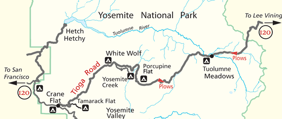
    some of these images are from a while back, right after the last bigger storm. The first one seems pretty current, rest is Badger Pass area and not from this week. Plows are coming across the pass from the east now, almost at Tuolumne Meadows, while from the west they still have many miles to go to meet the crews that came over from Mono County.

    plow positions on May 23:


  10. #70

    Default

    Quote Originally Posted by Dogwood View Post
    I don't think I possess some super human hiking skills or extra ordinary backpacking knowledge. If I can do that isn't it quite possible some others with the same equipment and skills could do the same on a more well traveled trail like the JMT in mid July at Yosemite NP, where in great likelyhood, they will not be the first to have traveled the JMT that yr?
    yeah, anything is possible, and with the right determination, you can probably hike the trail right now in trail runners. But you will need some serious dedication for that to succeed.

    This particular hiker arrived at the portal planning to do this on foot, not snow shoes or ski - thus the assumption that he is probably unaware of the true conditions out there right now.

    What are they like?

    May 12 ski tour report:
    http://www.facebook.com/media/set/?s...3&l=547923e3b9

    and one form a few days later in the Muir Pass region - around May 16 I think

    https://www.facebook.com/media/set/?...6&l=97a71b9ddc

    Hike that without ski or show shoes? good luck with that. It has snowed some more since the last set of images was posted.

    And in late May, the JMT is anything but "well traveled" - a few touring ski folks, a few every other day at best, and very few following the JMT. Maybe 3 or 4 do it per year at best. The rest may be some well equipped PCT hikers, but many of them simply skip the Sierra and come back in later season to stay on schedule. Few have time to wait out the thaw, and I bet even fewer would have the gear to deal with the mid May conditions this year. Basically, snow shoes or ski are the only mode of transportation right now.

    The Yosemite plow crews report 15 feet on the road well below Tuolumne Meadows. There probably are about 30-40 feet around Muir Pass.

  11. #71

    Default

    Quote Originally Posted by tuswm View Post
    I am worried about MPD, having to pay for gear I will never use again, and impossible creek crossings. and by worried I mean excited.
    impossible creek crossings? Not on the JMT unless you hit the peak thaw day of the year and then you always have the option to cross country up stream for a mile or two and find an easier crossing (Bear Creek for sure, Evolution gets easier just a few hundred feet upstream from the normal crossing).

    The thing I'd worry about in early season is the sheer number of wet crossings - compared to a late season trip when you may have one or two wet crossings, you can have 3 or 4 per day in some sections when the water is still coming down hard. That will slow you down and present hard to cross streams in places they usually are not expected. Careful on those that aren't labeled as 'major crossings' - because with enough water some of those are actually more dangerous than the relatively slow flowing Bear and Evolution Creek.

    The hardest crossings from 2009 and 2010 were creeks I don't even know the name off without pulling out a map - one was the second crossing south of Sivler after you drop down the steep switchbacks (mono creek?) and the other was a stream about 45 minutes above Woods Creek on the steep downhill from Pinchot. It usually is dry or easily boulder-hopped, but when were there there in 2009, it was a raging whitewater torrent and almost swept us off our feet. Similar situation at the creek below Silver Pass last year. One person lost a hiking pole - the water just ripped it out of her hand, and many of the others made the smart choice to keep their hiking boots on their feet for better and safer footing. Wet boots are much easier to deal with than a fall in those streams.

    remember to always unbuckle that backpack when crossing, use poles for extra legs, move one point at a time so you always have a tripod safely on the ground. In most streams it really helps to set hiking poles to a much taller setting than what is comfortable on normal trails, since they dig in between boulders you walk on.

  12. #72
    Saw Man tuswm's Avatar
    Join Date
    11-14-2008
    Location
    Philly/ OC MD
    Age
    43
    Posts
    776
    Images
    25

    Default

    Quote Originally Posted by Helmuth.Fishmonger View Post
    In most streams it really helps to set hiking poles to a much taller setting than what is comfortable on normal trails, since they dig in between boulders you walk on.
    Thats good advice
    "you cant grow old if you never grow up" ~TUswm

  13. #73

    Default

    another good link to keep an eye on is the Happy Isle water gauge webcam

    http://ca.water.usgs.gov/webcams/happyisles/

    the graph link on it shows you a flow rate history over a few days - gives you a good idea on trending. Right now the river is almost as high as it gets at 1690 ft³/s

    I think it can get up to about 2000 on really hot spring days. So if you see these numbers drop back before your hike, you'll know the worst is over.

  14. #74

    Default

    another cool link
    http://waterwatch.usgs.gov/new/index...&id=ww_current

    click on the sites in Yosemite. I just pulledup the Tuolumne above Hetch Hetchy and got this graph for peak flow historic data compared to today:

    http://waterwatch.usgs.gov/new/wwapp...te_no=11274790

    based on that, I'd expect our peak this year to be in mid June and perhaps higher than in 2010, so right now we are probably at 60% of peak. It's been cold up there, with snow likely today in the upper elevations around Mammoth again.

    The same site showed me that for Happy Isles, the record flow was 13.27 feet (5.39 today) back in 1997. The big snow years don't necessarily create those high stages, as 2010 peaked at 8.06 and 2006 isn't even listed (lots of snow) and even the 1982 snow year is not on that list. So runoff probably has a lot to do with temperatures, and not necessarily with snow depth. Obviously, lots of snow means a good chance to get a lot of runoff, however, peak for 2010 was in late October, and the other years show mid winter dates, not spring flow!

  15. #75

    Default

    ...yeah, anything is possible, and with the right determination, you can probably hike the trail right now in trail runners. But you will need some serious dedication for that to succeed.

    And in late May, the JMT is anything but "well traveled" - a few touring ski folks, a few every other day at best, and very few following the JMT. Maybe 3 or 4 do it per year at best. The rest may be some well equipped PCT hikers, but many of them simply skip the Sierra and come back in later season to stay on schedule. Few have time to wait out the thaw, and I bet even fewer would have the gear to deal with the mid May conditions this year. Basically, snow shoes or ski are the only mode of transportation right now.

    Notice carefully what I said!

    "I don't think I possess some super human hiking skills or extra ordinary backpacking knowledge. If I can do that isn't it quite possible some others with the same equipment and skills could do the same on A MORE WELL TRAVELED trail like the JMT IN MID JULY at Yosemite NP, where in great likelyhood, they will not be the first to have traveled the JMT that yr? Do folks believe the whole JMT will be under snow in mid July?"

    I was not speaking about hiking the JMT right now! I was not speaking about conditions or hiking in mid- late May on the JMT or in the Sierras! I was not speaking about PCTers or JMTers thruing the Sierras in mid MAY! Please keep in context what I've stated. ALSO, since you(Helmuth) and myself have been following a few perspective JMTers on other thread s here on WB we should already be aware of their aniticipated start times, direction of travel, etc.

  16. #76
    AT 4000+, LT, FHT, ALT Blissful's Avatar
    Join Date
    07-14-2005
    Location
    Virginia, 10 miles from the AT near SNP
    Age
    61
    Posts
    10,470
    Journal Entries
    1
    Images
    171

    Default

    Well I'm changing footwear to my Salomon gtx boots (I'd love to wear trail runners but can't with the likely kick steps to get up and down snowy passes. Still had a pair left that is really unused) and just got some better water crossing shoes rather than flimsy crocs. Will also get gaiters. We have already gotten a new tent. I plan to do this thing if at all possible.
    Ice ax needed by mid July this year?


    Hiking Blog
    AT NOBO and SOBO, LT, FHT, ALT
    Shenandoah NP Ridgerunner, Author, Speaker


  17. #77

    Default

    Maybe 3 or 4 do it per year at best. The rest may be some well equipped PCT hikers, but many of them simply skip the Sierra and come back in later season to stay on schedule. Few have time to wait out the thaw, and I bet even fewer would have the gear to deal with the mid May conditions this year. Basically, snow shoes or ski are the only mode of transportation right now. - Helmuth


    Well, it's mostly front runners on a NOBO PCT thru that would be hitting Kennedy Meadows/southern Sierras in early-mid May. And those that were planning on being through the Sierras that early would be aware of trail conditions. Most of the PCT NOBO masses typically hit KM between the first and third weeks of June. And, I'll venture that many(most?, all?) PCTers will be advised of this yr's snowfall, how fast it's melting, and suggested Sierra entry date as posted on www.postholer. For the most part PCTers will plan their Sierra entry dates well and adjust their hikes and hiking rates according to trail conditions where necessary. By May/early June NOBO PCT thru-hikers have come a long way already so they are seasoned hikers and in thru-hiker mode. I'll venture, unless trail conditions are truely horrendous in early-mid June most of the PCT masses will not skip the Sierras at that time. That's why I suggest one doing a JMT SOBO thru-hike starting in early July ay Happy Isles consult these hikers or the PCT-L website for on trail conditions. The most up to date trail conditions known, obviously, the better a JMTer can prepare!


    True, not every hiker can wait for trail conditions to improve, but some NOBO PCTers
    DO hold up at KM waiting for last minute gear to arrive to match the Sierra hiking conditions and/or wait on resupplies to arrive. Even thru-hikers are not run away trains. They can and do alter their hikes to be in certain places on certain dates according to trail conditions.

    Ice ax needed by mid July this year? - Blissful


    This is a common question for JMTers and certainly with some PCTers. Some struggle with the decision. Most likely not, IMO, but you have to ask yourself how comfortable you feel traveling on snow or ice IF you have to do that in mid July? How extensive is the snow travel/cover?; that's BIG consideration to some! What might the conditions of the snow be IF you do have to travel on it? For example, can you just kick step your way over and down soft snow for short snow travel distances. If you are concerned about it might I suggest you buy or borrow an ice axe(CAMP makes one of the lightest ones and is tuely an Ice axe for about $100), have it in the wings waiting, if AFTER making yourself known of trail conditions JUST PREVIOUS to your start date in July you think snow and ice still might pose a significant issue for you on the JMT passes, then take it along. You still have about five weeks before your SOBO JMT start though. Much can change!


    At the expense of repeating myself, relate your concerns to NP Backcountry Rangers. They are an excellent resource for the most up to date(early July) trail conditions.


    It may just be my illusion but it's my best guess a SOBO JMTer starting at Happy Isles in early July this year will not be faced with some kind of winter wonderland hike as illustrated in the pics above! They might very well experience patches of snow/ice on the passes, on north facing and shady slopes, and a few cold waist deep and possibly swift fords. But, all that is opinion. You don''t know for sure what you will be faced with until you check out trail conditions just prior to setting off on your hike.

  18. #78
    AT 4000+, LT, FHT, ALT Blissful's Avatar
    Join Date
    07-14-2005
    Location
    Virginia, 10 miles from the AT near SNP
    Age
    61
    Posts
    10,470
    Journal Entries
    1
    Images
    171

    Default

    Thanks, helpful stuff.


    Hiking Blog
    AT NOBO and SOBO, LT, FHT, ALT
    Shenandoah NP Ridgerunner, Author, Speaker


  19. #79

    Default

    Quote Originally Posted by tuswm View Post
    I am worried about MPD, having to pay for gear I will never use again, and impossible creek crossings. and by worried I mean excited.
    If I recall correctly, you are hiking with your wife/GF on her first real long hike, you have a wedding to get back to on the other side of the country, have rather tight set travel arrangements, have a SOBO JMT start date at Happy Isles in the thrd week of July, and are anticipating avg 14 MPD?


    Considering all that, and some other things you already mentioned, and barring injury, you should be able to attain your avg MPD! Some days may be more challenging. Some days you may do more MPD than 14. Some days, perhaps, you will hike less miles. When it's all said and done you should be able to acheive what you initially planned!


    Whether or not your other travel arrangements work out or if they flow smoothly without any major hiccups depends on how you made them. I think we went into some detail already concerning those potential issues on the thread started by you, Help With Timing Issues?


    If you are referring to buying gear like ice axes and/or crampons, IMO, I can't see a GREAT need of that gear starting a SOBO JMT thru from Happy Isles in the third wk of July. BUt, check trail conditions just before heading to Cali! Make final adjustments as needed!


    Creek crossings in July should be approached with care, possibly more so this yr! HF, on this thread, and Fiddleback, on another thread, offered some solid stream crossing tips. Go back and read them again if you forgot their posts. I believe HF mentioned the most likely potentially hazardous stream crossings. If the water is of high volume(you might inquire of this at the BC Ranger Office!) perhaps you can time it to make those fords with the GF in the morn when streams are typically lower from snowmelt. Stream crossings will not be impossible in late July! Ask about stream levels and possible fording idea from the NP Rangers! You and your GF know how to swim, right? LOL.


    Tusm, IMO, you are more prepared than most JMTers! Have a good time. Make that flight back home or you'll be in the doghouse with the GF!

  20. #80

    Default

    Quote Originally Posted by Dogwood View Post
    ...yeah, anything is possible, and with the right determination, you can probably hike the trail right now in trail runners. But you will need some serious dedication for that to succeed.

    And in late May, the JMT is anything but "well traveled" - a few touring ski folks, a few every other day at best, and very few following the JMT. Maybe 3 or 4 do it per year at best. The rest may be some well equipped PCT hikers, but many of them simply skip the Sierra and come back in later season to stay on schedule. Few have time to wait out the thaw, and I bet even fewer would have the gear to deal with the mid May conditions this year. Basically, snow shoes or ski are the only mode of transportation right now.

    Notice carefully what I said!

    "I don't think I possess some super human hiking skills or extra ordinary backpacking knowledge. If I can do that isn't it quite possible some others with the same equipment and skills could do the same on A MORE WELL TRAVELED trail like the JMT IN MID JULY at Yosemite NP, where in great likelyhood, they will not be the first to have traveled the JMT that yr? Do folks believe the whole JMT will be under snow in mid July?"

    I was not speaking about hiking the JMT right now! I was not speaking about conditions or hiking in mid- late May on the JMT or in the Sierras! I was not speaking about PCTers or JMTers thruing the Sierras in mid MAY! Please keep in context what I've stated. ALSO, since you(Helmuth) and myself have been following a few perspective JMTers on other thread s here on WB we should already be aware of their aniticipated start times, direction of travel, etc.
    so you missed the whole part about the guy who just started?

    what were you replying to then?

Page 4 of 9 FirstFirst 1 2 3 4 5 6 7 8 ... LastLast
++ New Posts ++

Posting Permissions

  • You may not post new threads
  • You may not post replies
  • You may not post attachments
  • You may not edit your posts
  •